Active Event
Tropical Update – September 19, 2019
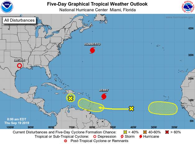
Tropical Weather Outlook
NWS National Hurricane Center Miami FL
800 AM EDT Thu Sep 19 2019
For the North Atlantic…Caribbean Sea and the Gulf of Mexico:
The National Hurricane Center is issuing advisories on Hurricane
Humberto, located several hundred miles northeast of Bermuda,
and on Tropical Storm Jerry, located several hundred miles east of
the Leeward Islands.
1. A tropical wave located about 1000 miles west of the Cabo Verde
Islands is producing disorganized cloudiness and showers. Some
development of this system is possible while the system approaches
the Windward Islands this weekend or when it moves across the
eastern Caribbean Sea early next week.
* Formation chance through 48 hours…low…near 0 percent.
* Formation chance through 5 days…low…30 percent.
2. An elongated area of low pressure associated with a tropical wave
is located just south of the Dominican Republic. Although
upper-level winds are not conducive for significant development,
thunderstorm activity has become more concentrated since yesterday.
Some slight development is still possible before the system begins
to interact with the high terrain of Hispaniola. Regardless of
development, locally heavy rainfall is possible over portions of the
Dominican Republic and Haiti during the next day or two. The
disturbance is forecast to move slowly northwestward through the
weekend.
* Formation chance through 48 hours…low…10 percent.
* Formation chance through 5 days…low…10 percent.
3. A tropical wave is forecast to move off the west coast of Africa in
a few days. Environmental conditions are expected to be conducive
for at least gradual development thereafter while the system moves
westward over the far eastern tropical Atlantic.
* Formation chance through 48 hours…low…near 0 percent.
* Formation chance through 5 days…low…20 percent.
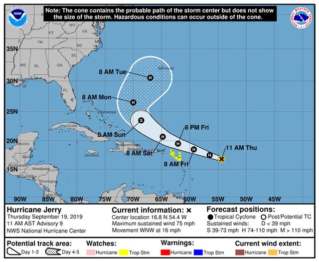
Tropical Storm Jerry – September 18, 2019
TS Jerry has formed in the Atlantic and looks like based on the official forecast that most land masses will be missed. At the end of five days the NHC forecast has TS Jerry turning and may not pose a threat to the US Coast. Still a long way out, so keep watching.
Tropical Storm Jerry Discussion Number 5
NWS National Hurricane Center Miami FL AL102019
1100 AM AST Wed Sep 18 2019
Satellite images indicate that Jerry continues to become better
organized, with a large curved band wrapping around the center.
While microwave data does not show an inner core yet, the overall
satellite presentation has improved during the past several hours.
The initial wind speed is set to 45 kt, which closely matches
almost all of the available Dvorak estimates and a just-arrived
ASCAT-C scatterometer pass.
Further intensification of Jerry is expected during the next day or
two as the cyclone moves over very warm waters within light shear.
While this type of environment could support even more
strengthening than forecast, there is some substantial dry air
around the cyclone, which is forecast to limit the intensification
rates for now. This forecast leans heavier on the regional
hurricane models HWRF, HMON and COAMPS-TC, which all show a weaker
cyclone than the statistical/dynamical LGEM and SHIPS models.
Most of the guidance shows increasing shear in a couple of days, and
the shear could become somewhat strong by next week. While little
change in strength is indicated beyond Friday, this usually doesn’t
happen in reality, and further changes will be necessary as the
environmental factors become more clear.
The initial motion continues to be west-northwestward, or 290/12
kt. The subtropical ridge to the north should steer Jerry at a
faster forward speed for the next couple of days. Afterward, a
northwest to north-northwestward turn, influenced by a weakness in
the aforementioned ridge left behind by Humberto, is expected. The
NHC track forecast is basically an update from the previous advisory
and lies on the left side of the guidance suite, nearest the ECMWF
model and the corrected-consensus forecasts.
Key Messages:
1. Jerry is expected to strengthen and be a hurricane when it moves
near the northern Leeward Islands Friday, although it is too soon to
determine the direct impacts to the islands. Interests there should
ensure they have their hurricane plan in place and monitor the
progress of this system. Watches could be issued for a portion of
this area this afternoon or evening.
FORECAST POSITIONS AND MAX WINDS
INIT 18/1500Z 14.6N 49.2W 45 KT 50 MPH
12H 19/0000Z 15.3N 51.0W 55 KT 65 MPH
24H 19/1200Z 16.3N 53.7W 60 KT 70 MPH
36H 20/0000Z 17.3N 56.5W 65 KT 75 MPH
48H 20/1200Z 18.4N 59.5W 65 KT 75 MPH
72H 21/1200Z 20.5N 65.3W 65 KT 75 MPH
96H 22/1200Z 23.3N 69.1W 65 KT 75 MPH
120H 23/1200Z 26.5N 70.5W 60 KT 70 MPH
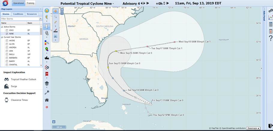
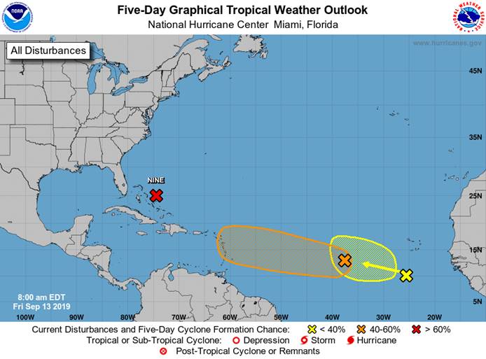
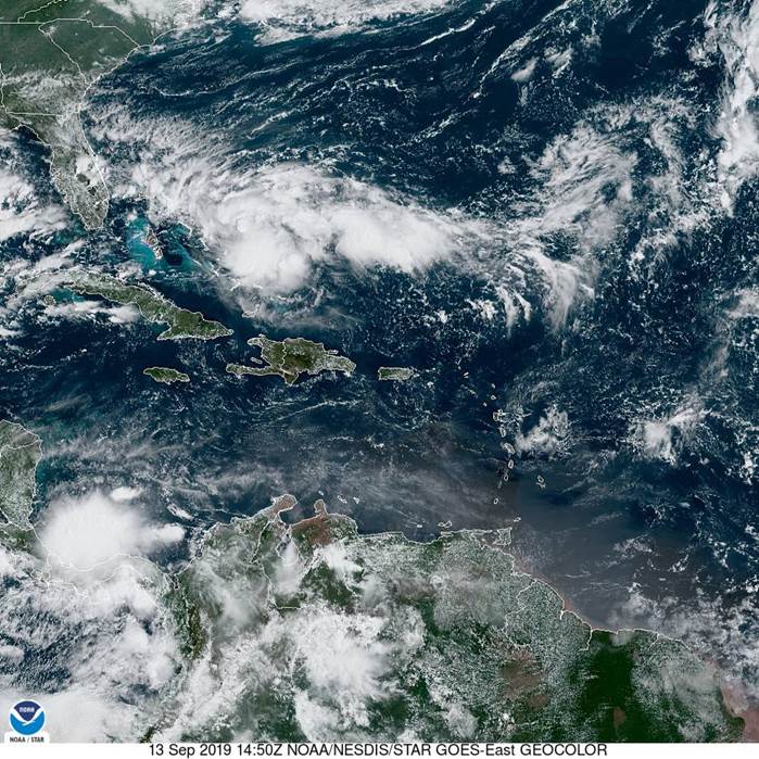
Tropical Weather Update – September 13, 2019
Potential Tropical Cyclone Nine Discussion Number 4
NWS National Hurricane Center Miami FL AL092019
1100 AM EDT Fri Sep 13 2019
Preliminary data from a reconnaissance plane indicate that the
disturbance has not developed a well-defined center yet and
continues to be characterized by an elongated SW to NE trough of low
pressure. Satellite images however, suggest that the system could
be consolidating a little bit farther to the east within the area of
deep convection. The reconnaissance plane will also check this
region soon. In this advisory, the initial position is a point near
the middle of of the trough, but not quite as far east as the
convective area. The initial intensity remains 25 kt.
The disturbance is embedded within a moderate shear environment, but
this parameter is not expected to be strong enough to halt
development. The NHC forecast still calls for this system to
become a tropical cyclone later today or Saturday. Global models
develop the system and guidance suggests that the cyclone could even
reach hurricane intensity by the end of the forecast period. By
then, the system is expected to be over the Atlantic well southeast
of the coast of the Carolinas.
Due to a lack of a well-defined center, the initial motion is highly
uncertain. It appears that there has been little motion during
the past few hours. A weakness in the ridge over the western
Atlantic is forecast to develop and this pattern should steer the
system slowly toward the northwest and then northward. In about 3
days, an eastward moving mid-latitude trough will force the system
to recurve away from the coast toward the Atlantic. The guidance
has shifted a little to east this morning and consequently the NHC
track forecast was adjusted in that direction. However, the official
forecast is still on the western edge of the guidance envelope. If
the disturbance develops a little more to the east, the track
forecast will probably adjusted to the right later tod
Update Hurricane Dorian – September 6, 2019
Hurricane Dorian Discussion Number 52
NWS National Hurricane Center Miami FL AL052019
500 AM EDT Fri Sep 06 2019
The center of the eye of Hurricane Dorian is located just off the
coast of North Carolina not far from Cape Lookout. Based on data
from the Air Force Hurricane Hunters and Doppler radar velocities,
the initial intensity is set at 80 kt. This estimate is a
compromise between the flight-level winds and SFMR values. The
minimum pressure remains quite low, 956 mb, based on surface
observations and aircraft fixes. There have been several reports in
eastern North Carolina of sustained tropical-storm-force winds and
hurricane-force gusts, with the strongest winds being reported in
the northern eyewall.
Dorian is moving northeastward at 12 kt. A faster northeastward
motion is expected during the next few days as a mid- to upper-level
trough, currently over the U.S. Great Lakes, approaches the system
and accelerates the steering flow. This track forecast takes the
hurricane along the coast of North Carolina during the next several
hours and near or over Atlantic Canada this weekend. The models
are tightly clustered, and the NHC track forecast lies near the
middle of the guidance envelope.Hu
The hurricane is expected to gradually weaken during the next couple
of days due to an increase in wind shear and drier air. Dorian is
expected to cross the north wall of the Gulf Stream current in about
36 hours, and head over much colder waters after that. These
atmospheric and oceanic conditions should cause the cyclone to
become a powerful hurricane-force extratropical in about 2 days. As
the system gains latitude, the tropical-storm-force winds are
expected to expand significantly. The NHC intensity forecast is
largely an update of the previous one and in line with the various
consensus aids.
Key Messages:
- Life-threatening storm surge and dangerous winds are expected
to continue along portions of the North Carolina coast, portions of
southeast Virginia and the southern Chesapeake Bay. Water levels
could rise well in advance of the arrival of strong winds. Residents
in these areas should follow advice given by local emergency
officials.
- Flash flooding is occurring, and will continue to become more
widespread across the eastern Carolinas and far southeast Virginia
this morning. There is a high risk of flash flooding over these
areas, where significant, life-threatening flash flooding is
expected.
FORECAST POSITIONS AND MAX WINDS
INIT 06/0900Z 34.6N 76.2W 80 KT 90 MPH
12H 06/1800Z 36.0N 74.1W 75 KT 85 MPH
24H 07/0600Z 38.8N 69.9W 75 KT 85 MPH
36H 07/1800Z 42.5N 65.4W 70 KT 80 MPH
48H 08/0600Z 46.7N 61.6W 60 KT 70 MPH…POST-TROP/EXTRATROP
72H 09/0600Z 53.0N 52.0W 45 KT 50 MPH…POST-TROP/EXTRATROP
96H 10/0600Z 58.0N 36.0W 40 KT 45 MPH…POST-TROP/EXTRATROP
120H 11/0600Z 0.0S 0.0W 0 KT 0 MPH…DISSIPATED
Pender County Hurricane Dorian Update – September 5, 2019
To All,
Hopefully by now everyone has taken the precautions for the storm. While the storm bares down on us please do be out after 8 pm that is when the curfew takes effect. All EOC’s in the County are operational and will remain open to until. Please Be safe.
———————————————————————————————————————————————————————————————————————————————————————————————-
Hurricane Dorian Discussion Number 50
NWS National Hurricane Center Miami FL AL052019
500 PM EDT Thu Sep 05 2019
During the last 12 h, Dorian appears to have started the expected
slow weakening trend. Air Force Reserve Hurricane Hunter data show
that the central pressure inside the 35-45 n mi wide eye is slowly
rising, and satellite imagery indicates that the eye is becoming
less well defined. The current Hurricane Hunter aircraft has
reported maximum SFMR surface wind estimates of 88 kt, along with
700 mb flight-level winds of 91 kt. Based on these data, the initial
intensity is reduced to 90 kt.
The hurricane is continuing its expected northeastward turn, and the
initial motion is now 035/9. The mid-latitude westerlies should
steer Dorian generally northeastward at an increasing forward speed,
with the eye passing near of over portions of the North Carolina
coast during the next 12-24 h. After that, Dorian is forecast to
move quickly across the northwest Atlantic and be near or over the
Canadian Maritimes/Atlantic provinces by 60 h. As was the case in
the previous advisory, the track guidance remains tightly clustered,
and the new forecast track is changed little from the previous
one.
Due to increasing shear, Dorian is forecast to slowly weaken as it
moves near and along the South and North Carolina coasts.
Extratropical transition should begin around 36-48 h and be complete
by 60 h, although Dorian is forecast to maintain hurricane-force
winds through the transition. After transition is complete, the
extratropical low should weaken over the far north Atlantic and be
absorbed into a larger low pressure area by 120 h.
The center of Dorian is expected to move very near or over the
coastline of the Carolinas and the southern Mid-Atlantic states.
Residents of these areas should already be prepared for damaging
winds, life-threatening storm surges, and flooding rains. It also
appears that Dorian will affect portion of eastern Canada as a
hurricane-force extratropical low.
Key Messages:
1. Life-threatening storm surge and dangerous winds are expected
along portions the coasts of South Carolina and North Carolina, and
portions of southeast Virginia and the southern Chesapeake Bay,
regardless of the exact track of Dorian’s center. Water levels
could rise well in advance of the arrival of strong winds. Residents
in these areas should follow advice given by local emergency
officials.
2. Flash flooding is occurring, and will continue to become more
widespread across the eastern Carolinas and far southeast Virginia
through tonight. There is a high risk of flash flooding over these
areas, where significant, life-threatening, flash flooding is
expected.
FORECAST POSITIONS AND MAX WINDS
INIT 05/2100Z 33.1N 78.5W 90 KT 105 MPH
12H 06/0600Z 34.2N 77.2W 90 KT 105 MPH
24H 06/1800Z 36.0N 74.4W 85 KT 100 MPH
36H 07/0600Z 38.5N 70.4W 80 KT 90 MPH
48H 07/1800Z 42.0N 65.9W 75 KT 85 MPH
72H 08/1800Z 50.0N 57.5W 65 KT 75 MPH…POST-TROP/EXTRATROP
96H 09/1800Z 56.0N 45.5W 50 KT 60 MPH…POST-TROP/EXTRATROP
120H 10/1800Z 0.0S 0.0W 0 KT 0 MPH…DISSIPATED
Update – Hurricane Dorian – September 5, 2019
To All,
Hurricane Dorian’s center is roughly 220 miles from our coast line and the eye forecasted to be about 25 miles off shore. We are now experiencing the outer bands that have strong winds and short lived tornadoes. As the day goes on the weather will deteriorate. If you are not ready it is not too late. If you or anyone you know needs shelter get to the shelter as soon as possible, before it gets too bad. Please do not go out during this storm. The worst is yet to come.
Hurricane Dorian Discussion Number 48
NWS National Hurricane Center Miami FL AL052019
500 AM EDT Thu Sep 05 2019
Dorian continues to exhibit a large eye of about 50 n mi in
diameter on satellite and radar images. Earlier data from
hurricane hunter aircraft indicate little change to the minimum
central pressure, and flight-level winds still support an intensity
close to 100 kt at this time. Dorian should soon begin to
experience increasing southwesterly shear, which should lead to at
least slow weakening during the next couple of days. The official
forecast maintains the cyclone at hurricane strength through 72
hours, which is in general agreement with the LGEM guidance and on
the high side of the guidance suite. By 72 hours, the global models
show Dorian becoming embedded within a baroclinic zone, and
simulated satellite imagery from the ECMWF model depicts a highly
asymmetric cloud pattern. Therefore, the NHC forecast shows the
system becoming extratropical by that time.
Dorian’s initial motion is about 010/6 kt. The hurricane is
currently moving through a break in the subtropical ridge. Within
a day or so, the cyclone should turn northeastward with increasing
forward speed in response to a broad mid-tropospheric trough to the
north. The official track forecast remains in good agreement with
the dynamical model consensus. The forecast track and wind radii
now require the issuance of a tropical storm watch for extreme
southeastern New England.
The center of Dorian is still expected to move very near or over
the coastline of the Carolinas and the southern Mid-Atlantic
states. Residents of these areas should already be prepared for
damaging winds, life-threatening storm surges, and flooding rains.
Key Messages:
1. Life-threatening storm surge and dangerous winds are expected
along portions the coasts of South Carolina and North Carolina, and
portions of southeast Virginia and the southern Chesapeake Bay,
regardless of the exact track of Dorian’s center. Water levels
could rise well in advance of the arrival of strong winds.
Residents in these areas should follow advice given by local
emergency officials.
2. Flash flooding will become increasingly likely across the eastern
Carolinas today. There is a high risk of flash flooding over
coastal sections of the Carolinas where life-threatening flash
flooding is expected.
FORECAST POSITIONS AND MAX WINDS
INIT 05/0900Z 31.7N 79.5W 100 KT 115 MPH
12H 05/1800Z 32.7N 78.9W 95 KT 110 MPH
24H 06/0600Z 34.2N 77.2W 90 KT 105 MPH
36H 06/1800Z 36.1N 74.5W 85 KT 100 MPH
48H 07/0600Z 38.3N 70.8W 80 KT 90 MPH
72H 08/0600Z 46.0N 61.5W 65 KT 75 MPH…POST-TROP/EXTRATROP
96H 09/0600Z 53.0N 52.5W 50 KT 60 MPH…POST-TROP/EXTRATROP
120H 10/0600Z 58.0N 38.0W 40 KT 45 MPH…POST-TROP/EXTRATROP