Public Notices
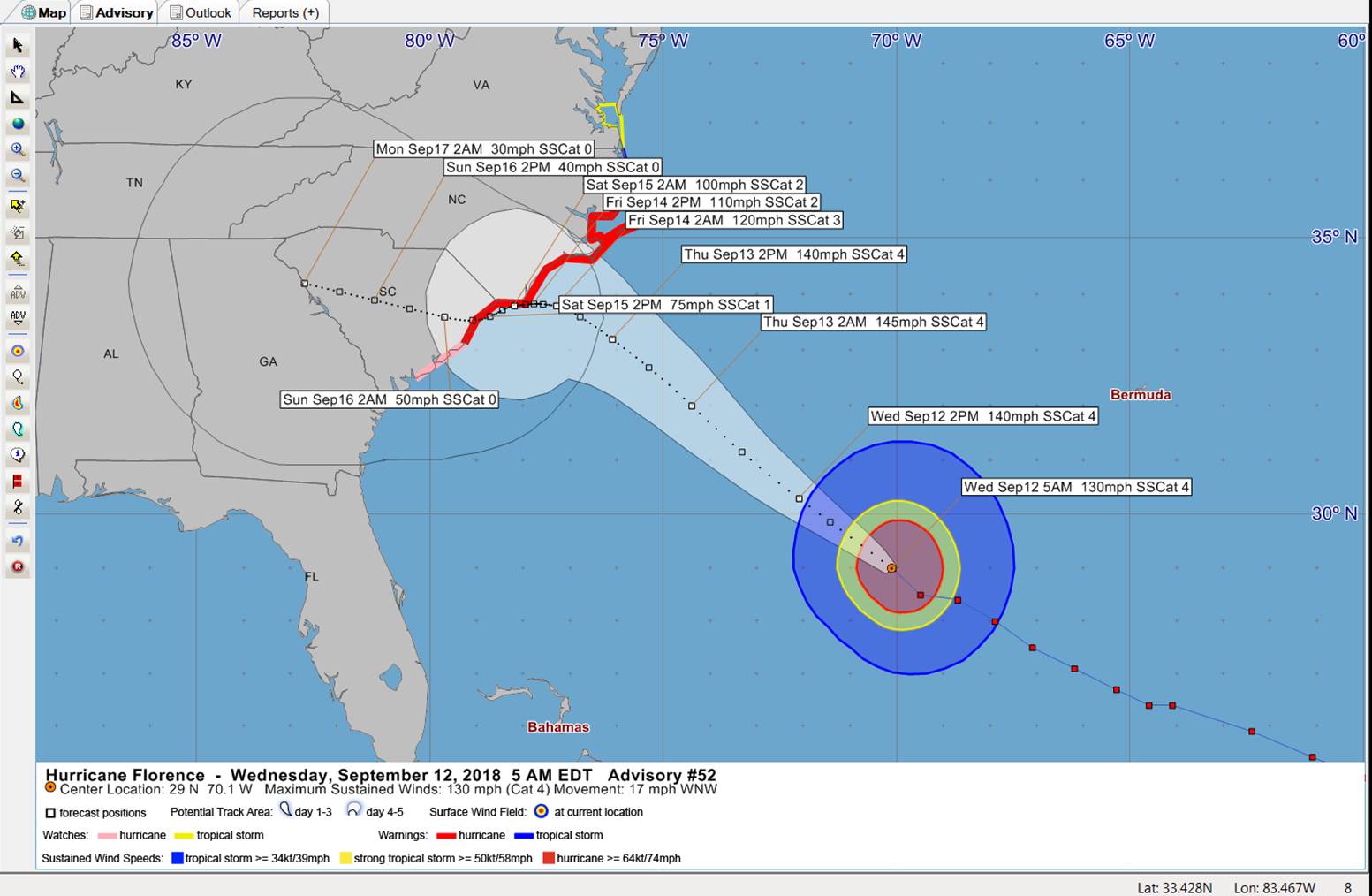
Tropical Update – Hurricane Florence – September 12, 2018
To All,
If you look at the forecast, you can see how things can change. This is still a very dangerous storm and will be a long duration event. Be safe, stay safe.
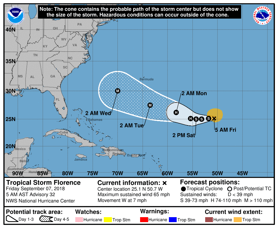
Tropical Update #2 – September 7, 2018
To All,
The 11:00 am advisory has moved a little south, based on this advisory Hurricane Florence will be about 460 miles from our coast on Wednesday morning. Still early to tell exactly where Florence will make landfall, but we need to prepare now.
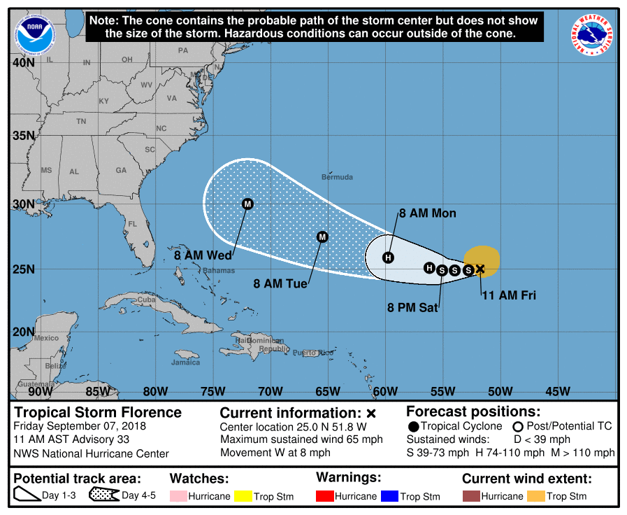
Tropical Storm Florence Discussion Number 33
NWS National Hurricane Center Miami FL AL062018
1100 AM AST Fri Sep 07 2018
Moderate to strong southwesterly shear continues to affect Florence,
but visible and microwave satellite images indicate that the
cyclone is maintaining a vigorous, but tilted, circulation.
A mid-level eye feature is noted in both types of satellite
imagery, but the low-level center still appears displaced to the
southwest. Subjective and objective satellite intensity estimates
have stopped falling–and some have even begun to increase a bit
again–so the initial intensity is being held at 55 kt.
The shear over Florence has likely reached its maximum and is
expected to decrease below 20 kt in 6-12 hours and then decrease to
10 kt or less in 36 hours. All the while, sea surface temperatures
will be gradually increasing to between 28-29C, and perhaps more
importantly, oceanic heat content values will double in 3-4 days.
It may take the cyclone some time to gather itself once the shear
abates, but once it becomes vertically stacked again, the intensity
is likely to increase significantly. The guidance is in agreement
on this scenario, and Florence is likely to re-attain hurricane
status in about 48 hours and then potentially major hurricane
strength by days 4-5. The new official forecast is fairly similar
to the previous one, generally close to the ICON intensity consensus
and slightly below the HCCA model on days 4 and 5.
Florence is moving westward, or 270/7 kt, to the south of the
eastern periphery of a subtropical ridge extending east of the
Mid-Atlantic United States. The global model guidance is actually
in fairly good agreement on the general evolution of the steering
pattern around Florence through day 5. While it remains a tilted
cyclone, Florence is expected to continue moving westward for the
next 48 hours. After that time, a break in the ridge should allow
Florence to turn west-northwestward over the southwestern Atlantic.
A new mid-level ridge is expected to develop over the western
Atlantic on days 4-5, but the position of that high will play a big
role regarding how much Florence may turn by the end of the
forecast period. Only a slight southward nudge of forecast track
was required on this cycle, keeping the NHC prediction between the
GFS and ECMWF solutions.
Key Messages:
1. Regardless of Florence’s eventual track, large swells will begin
to affect Bermuda later today and portions of the U.S. East Coast
this weekend, resulting in life-threatening surf and rip currents.
2. The risk of other direct impacts associated with Florence along
the U.S. East Coast next week has increased. However, there is
still very large uncertainty in model forecasts of Florence’s track
beyond day 5, making it too soon to determine the exact location,
magnitude, and timing of these impacts. Interests near and along
the U.S. East Coast should monitor the progress of Florence through
the weekend and ensure they have their hurricane plans in place.
FORECAST POSITIONS AND MAX WINDS
INIT 07/1500Z 25.0N 51.8W 55 KT 65 MPH
12H 08/0000Z 24.9N 52.8W 55 KT 65 MPH
24H 08/1200Z 24.9N 54.0W 55 KT 65 MPH
36H 09/0000Z 24.9N 55.1W 60 KT 70 MPH
48H 09/1200Z 25.1N 56.2W 65 KT 75 MPH
72H 10/1200Z 25.9N 59.8W 90 KT 105 MPH
96H 11/1200Z 27.5N 65.5W 110 KT 125 MPH
120H 12/1200Z 30.0N 72.0W 115 KT 130 MPH
$$
Forecaster Berg
Tropical Update – Friday, September 7, 2018
To All,
As you see below the error cone keeps getting closer to the coast of NC. By Monday or sooner, I think we will be in the error cone. This will prompt us to start our Hurricane preparations. Do not wait to start Monday for your family to get ready and have a plan. This current path will bring the storm very close to our area. We will be ready.
Also, in the back of your mind there are other systems we are keeping a close eye on. More to come.